This site's tour
From Hobart
Lookout, coast and Richmond
- Length10.5 hours
- GroupUp to 13
- Pickup19 Hobart points
Guides
Language
Currency
Check open spotsfrom $110 · no cancel feeYour stop on the map
See all 22 stops
Select a route, then tap a marker or stop to see its note and open Google Maps.
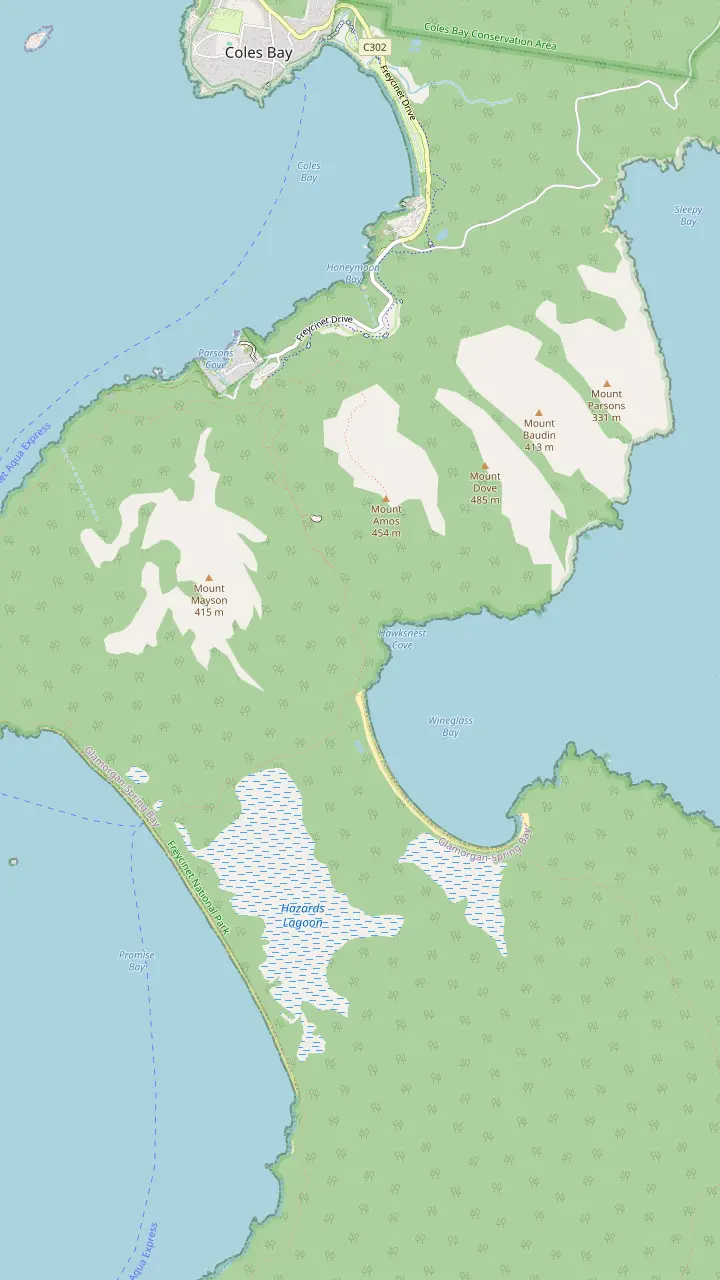
The walks car park has toilets and a water tap; the lookout track starts here.
Google MapsThe lookout platforms sit on the saddle, in a pass through the Hazards.
Google MapsMount Amos: 3 hours return over 3.6km, Grade 4, never when wet.
Google MapsThe beach is approximately 1000 stairs below the saddle.
Google MapsThe isthmus between the two beaches is an unusually wide tombolo.
Google MapsHazards Beach is the halfway point of the 11km circuit.
Google MapsThe walker campsite at the bay needs no booking and charges nothing.
Google Maps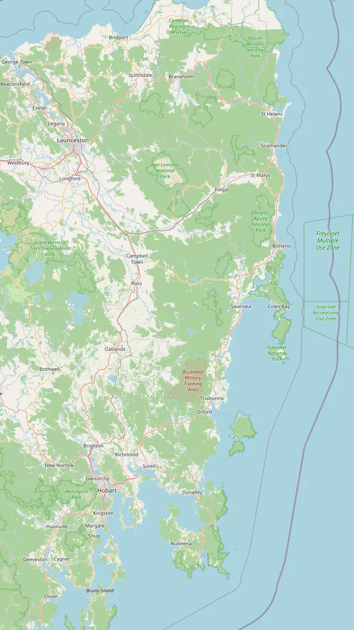
Hobart: Freycinet National Park is a 2hr 30min drive (195km) to the north-east.
Google MapsRichmond is the village this site's tour visits for 30 minutes on the way back to Hobart.
Google MapsSwansea looks across Great Oyster Bay to the pink peaks of the Hazards.
Google MapsColes Bay is the peninsula's sole town and the gateway to the park.
Google MapsBicheno is 39km, about 30 minutes, from Freycinet.
Google MapsLaunceston: the park is a 2hr drive (175km) to the south-east.
Google Maps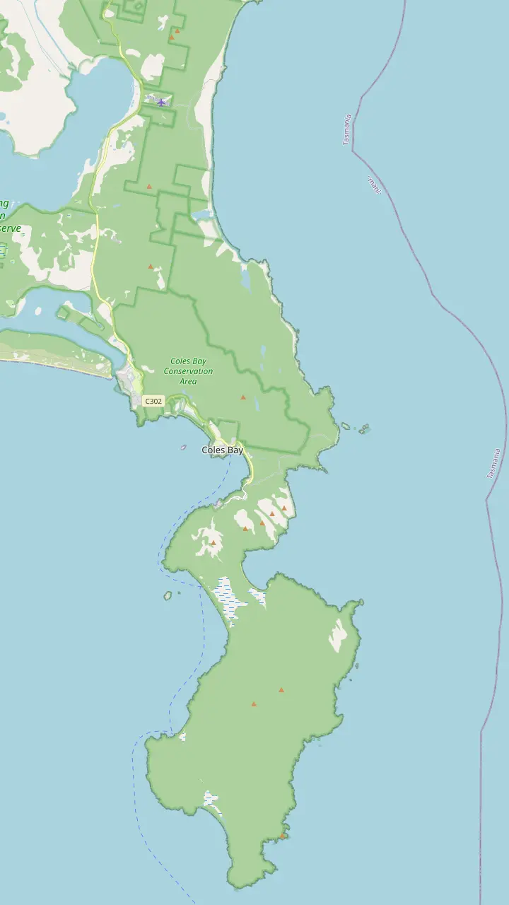
The visitor centre at the park entrance opens daily from 9am to 4pm and sells park passes.
Google MapsThe Friendly Beaches: more than 10km of sand; swimming is not recommended.
Google MapsCape Tourville: a 20 minute, 600m boardwalk circuit around the lighthouse.
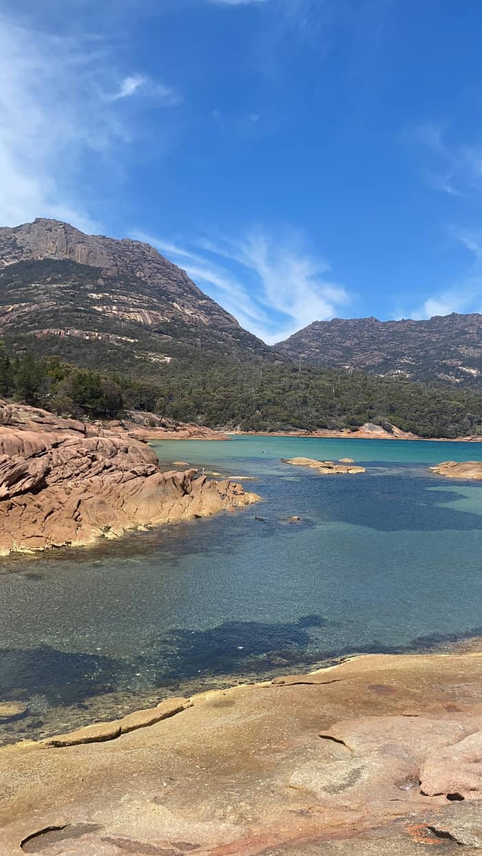
Google MapsSleepy Bay: 20 minutes return over 500m, to turquoise water and orange rocks.
Google MapsHoneymoon Bay: barbecues, picnic tables and a good sunset view of the Hazards.
Google MapsRichardsons Beach: the campground beside one of the east coast's most extensive shell middens.
Google MapsThe lookout platforms sit on the saddle, in a pass through the Hazards.
Google MapsCooks Beach has a small walker campsite on the peninsula circuit.
Google MapsMount Freycinet is the highest point on the peninsula.
Google MapsBluestone Bay lies on the park's ocean coast north of Cape Tourville.
Google Maps© OpenStreetMap contributors, map data
Where is Wineglass Bay? On the ocean side of the Freycinet Peninsula, on Tasmania's east coast, a drive of about 2.5 hours from Hobart or Launceston. Here is the map, the roads, the buses and the last stretch on foot.
Editorial team, freycinetnationalparktour.com · Updated November 8, 2026 · Quick read: 8 min
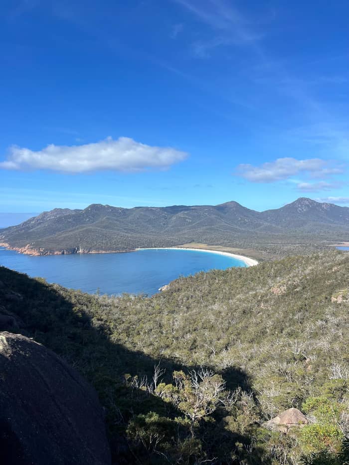
Wineglass Bay, Tasmania, lies on the Freycinet Peninsula, which juts out into the sea from the island's east coast.1 The bay sits on the peninsula's ocean side, where a strip of sand ties the granite of the Hazards, to the north, to the Mount Graham and Mount Freycinet massif in the south.5 From above, that isthmus is the white curve you see in every photograph, with the open sea in front of it.
The whole of Freycinet National Park is long and thin. Its management plan describes it as approximately 48 kilometres long, Schouten Island included, and up to 6 kilometres wide, with Great Oyster Bay to the west and the Tasman Sea to the east.6 The park also reaches north along the peninsula's east coast through the Friendly Beaches almost to Bicheno.7 The bay you came for is near the middle of the main section, a short walk from the end of the park road.
Coles Bay is the gateway. It is the only town on the peninsula, sitting beneath the pink granite of the Hazards and looking across Great Oyster Bay.8,9 The park entrance and the Freycinet Visitor Centre are just beyond it, and the visitor centre opens daily from 9am to 4pm.10,11 Everything in this guide funnels through that small township, so it is the name to type into your navigation app.
From each starting point
| From | To | Distance | Time |
|---|---|---|---|
| Hobart | The park | 195km | 2hr 30min |
| Hobart | Coles Bay | 192km | 2hr 30min |
| Launceston | The park | 175km | 2hr |
| Launceston | Coles Bay | 173km | 2hr 10min |
| Bicheno | Freycinet | 39km | About 30mins |
| Hobart | Swansea | 134km | 90min |
Distances and times as Discover Tasmania gives them; allow extra for stops.2,15,19,13
If you are working out how to get to Wineglass Bay from Hobart, the figures are simple. Discover Tasmania puts Freycinet National Park at a 2hr 30min drive, or 195km, north-east of Hobart.2 It gives Coles Bay as a 2hr 30min drive of 192km.15 The parks service is a little more cautious and puts Hobart about 2.5 to 3 hours away by road, a range that allows for stops and slower traffic.16
The route follows the Tasman Highway up the coast. Swansea, on Great Oyster Bay, is a 90min drive of 134km from Hobart, and from its shore the pink peaks of the Hazards stand across the water.13,17 About 7.5km south of Swansea is Spiky Bridge, built by convicts in 1843, a quick stop for leg-stretching.18 Further north, Bicheno is 178km from Hobart by the Tasman Highway.12 Much of the drive hugs the shore, with beaches and lagoons on the right.
The turn that matters comes before Bicheno. Leave the Tasman Highway (A3) for the Coles Bay Road (C302), 12km south of Bicheno.3 From the highway it is 28km on a sealed road, straight through the Coles Bay township, to the main park entrance and visitor centre.10 The road then runs on to the walking tracks car park, where the walks to the lookout and the bay begin.14 Watch for the signs as you leave the township: the road narrows and slows inside the park.
Coming to Wineglass Bay from Launceston is a slightly shorter drive. For Launceston, Discover Tasmania lists the park as 175km away, a 2hr drive to the south-east, and Coles Bay as 173km and 2hr 10min.2,15 For Bicheno it gives a route of 160km via the Lake Leake Highway, about 2hrs.12 Whichever road you take, you finish on the same Coles Bay Road turn-off south of Bicheno.3 The inland road crosses farmland and forest before it drops to the coast.
Day tours run from Launceston too. A guided active day meets at the Hotel Grand Chancellor on Cameron Street at 7.20am and comes back around 6.00pm, with the lookout walk at its center; the minimum age is 8 years and it is listed from $123. A second active day also departs Launceston at 7.20am but ends in Hobart, lasting 10.5 hours, from $151. That one-way option suits travelers crossing the island from north to south.
Launceston also works as the first stop of a longer loop. A road trip that starts in the north can take in the east coast, Freycinet and then Hobart, with a night or two in the coastal towns along the way. The practical point is the same from either city: allow a full day for the return drive and a walk, or stay a night on the peninsula and do it without hurrying. Driving tired on a winding road at dusk is the risk worth avoiding.
Pick your route
Start from where you are staying and whether you have a car.
If I am in Hobart with a car
Drive the east coast
195km and a 2hr 30min drive to the park.2
If I am in Launceston with a car
Drive south-east
175km and about 2hr to the park.2
If I am in Hobart without a car
Take the day tour
Pickup from 19 Hobart points and 10.5 hours with a guide.
If I am crossing from north to south
One-way tour
Launceston at 7.20am, finishing in Hobart.
If I want to avoid the stairs
Water taxi
A 30-minute cruise and a 2-kilometre walk to the bay.
Let someone else drive
This site's tour
Lookout, coast and Richmond
Return to Launceston
Active day and back
One-way crossing
Launceston to Hobart
Can you drive to Wineglass Bay? Not to the beach. The road stops at the car park for the walking tracks, and from there the sand is 6 km away and back, a Grade 3 walk of 2.5-3.5 hrs.14,4 First comes a steep climb of around 1.3km to the saddle, then a descent of approximately 1000 stairs to the sand.45,35 The lookout alone, without the descent, is 2.6 km return.46 Either way, the last part of the journey is on your own feet.
Boats help too. A water taxi crosses from the Coles Bay Boat Ramp to Hazards Beach in 30 minutes, and a 2-kilometre path over the isthmus then brings you to the bay; the listing sets no age or height limit. A catamaran cruise from Coles Bay rounds the tip of the peninsula and enters the bay itself for lunch, which shows it from the water without any walking at all.47
Whichever way you come, bring a parks pass. You need a valid pass to enter any Tasmanian national park, and the visitor centre shop at the entrance sells them.48,20 Staying close to the visitor centre? The Freycinet Walk and Cycle Track covers the 4km to the start of the walks, about 1 hour on foot, and spares you the hunt for a parking space.49 It is a pleasant warm-up before the climb.
Price check
Choose how many are travelling and see each day tour's from-price for the group.
Compare all 3 options
Choose how many are travelling and see each day tour's from-price for the group.
≈
View≈
View≈
ViewFigures are GetYourGuide from-prices, translated at the ECB reference rate. The booking step shows what you pay exactly.
The drive in order
Hobart
Take the Tasman Highway up the coast.12
Swansea
Swansea is 134km from Hobart, on Great Oyster Bay.13
Coles Bay Road
Take road C302, 12km south of Bicheno.3
Coles Bay
The park entrance is 28km from the highway.10
Visitor centre
Open daily 9am to 4pm.11
Car park
The lookout and beach walks begin here.14
Public transport works, but it needs planning. There is no regular passenger rail in Tasmania; buses fill the gap.50 Tassielink Transit has the widest regional network, reaching more than 50 towns across the regions and remote areas.51 On the east coast, Calow's Coaches runs the service between Coles Bay, Bicheno and Freycinet and links Bicheno and St Helens with Launceston and Hobart.52
Check the current timetable before you build a day around a bus. Calow's Coaches notes that from 17 May 2026 routes 743, 744 and 745 travel via Swanwick, and Discover Tasmania warns that schedules can change with the seasons.53,41 The operator no longer accepts e-bikes or e-scooters on its services.54 The parks service confirms that the park can be reached by public transport or on tours.55
A day tour removes every connection from the plan. This site's tour collects guests at 19 Hobart pickup points, the Tasmanian Travel & Information Centre included, for a 10.5-hour day in a group capped at 13 participants. It includes the lookout walk, Cape Tourville, Honeymoon Bay and a stop in Richmond, and it is listed from $110 with free cancellation up to 24 hours ahead.
Video
Michael B. Traveller on YouTube · Tap play to load the video; not before.
The main park entrance and Freycinet Visitor Centre are accessed by driving straight through the Coles Bay township, 28km from the highway on a sealed road
Before you leave
Book the car early. Discover Tasmania stresses that car hire should be booked well ahead, and summer is the busiest time of the year.40,56 Check your rental contract before leaving sealed roads: some include special conditions for unsealed roads, and the turn-off to the Friendly Beaches is gravel.44,57 Roads in Tasmania can be winding and steep, so leave extra time beyond the map's estimate.58
Fuel and daylight are the two things to manage. In remote areas some fuel stations shut by 5pm, so fill up before you head out to the peninsula for the evening.42 Native animals often wander onto roads between dusk and dawn, and the parks service asks visitors to avoid driving in its reserves at night where possible.59,43 Plan to be off the Coles Bay Road before dark, or stay the night nearby.
Inside the park, the road is short and slow. Drive gently past the visitor centre and campground, where people walk and cycle, and watch for walkers crossing near the car park. Where the walk and cycle track crosses a road, the parks service asks walkers and cyclists to stop and give way to vehicles.60 Park only in marked bays and leave space for coaches. On busy days, arrive early or come back later rather than circling the car park.
Coles Bay is the natural base. Discover Tasmania says the town caters to all budgets, from luxury stays and gourmet dining to caravan and camping facilities.61 Inside the park, camping at Richardsons Beach, Honeymoon Bay and Ranger Creek is popular enough that summer sites go to a ballot drawn in early August.62 Book well ahead if you want to sleep within walking distance of the visitor centre.
Bicheno, 39km and about 30 minutes north of Freycinet, is the next town up the coast and a base for the little penguin tours.19,63 It is a handy stop for supplies if you plan to camp in the park. Swansea, on the way from Hobart, has its views of the Hazards across Great Oyster Bay.17 Either works for a stay that splits the drive and leaves an early start for the lookout before the midday rush.64
Plan the whole trip around the light. The visitor centre opens at 9am, and an early arrival at the lookout gives quieter platforms and softer light on the bay.11,64 In summer, Discover Tasmania notes that daylight stretches past 9pm, which leaves long evenings for Honeymoon Bay and the Hazards at sunset.65,26 In winter the days are short, so start early and keep the drive back for daylight.
FAQ
By Discover Tasmania's figures the drive from Hobart is 195km, about 2hr 30min.2
Discover Tasmania gives a 2hr drive of 175km from Launceston to the park.2
Calow's Coaches runs the Coles Bay, Bicheno and Freycinet service.52
Coles Bay is a 2hr 30min drive of 192km north-east of Hobart.15
Entry to any Tasmanian national park needs a valid parks pass.48
Sources
More to read
Planning a day at Wineglass Bay? A real person answers here.